
- Voltage
- 500 kVAn overhead line from SDG&E's Imperial Valley Substation to a new 500/230 kV substation north of San Onofre, near the San Diego-Orange County line.
Sources: SDG&E; California Independent System Operator
- Length
- 135 to 151 milesSDG&E puts its preliminary corridor at about 151 miles. The CPUC says about 150, CAISO's planning figure is 145, and the Anza-Borrego Foundation says about 135.
Sources: SDG&E; California Public Utilities Commission; California Independent System Operator; Anza-Borrego Foundation
- Cost
- $1.6 to $2.3 billionSDG&E estimates about $1.624 billion from preliminary design. CAISO's 2023 estimate of about $2.28 billion covers a wider scope, including the new substation.
Sources: SDG&E; California Independent System Operator
- Who pays
- Ratepayers statewideSDG&E says costs are paid by customers across CAISO's system, and SDG&E's own customers would pay about 9%. SDG&E has not published a rate impact.
Source: SDG&E
- Tower height
- 140 to 200 ftSDG&E expects towers to average about 140 to 180 feet, on a right-of-way typically 180 to 200 feet wide. The City of Temecula says up to 191 feet; the Vista Irrigation District says just under 200. Six tower designs are under consideration.
Sources: SDG&E's answers to the City of Temecula, September 16, 2026 (posted by the City); City of Temecula; Vista Irrigation District; Learn more
- In service
- 2032SDG&E's target, with construction starting in fall 2029. CAISO's required in-service date is June 1, 2034.
Sources: SDG&E; California Independent System Operator
Taller than the Palomar dome
SDG&E's own average for its towers, drawn to scale beside the Hale Telescope's dome on Palomar Mountain.
- SDG&E's expected average: 140 to 180 ft
- SDG&E expects tower heights to average about 140 to 180 feet, depending on where towers go, how far apart, and the terrain. Solid tower: 140. Dashed outline: 180.
Source: SDG&E
- Up to 191 ft, the City of Temecula says
- The Vista Irrigation District says just under 200 feet.
Sources: City of Temecula; Vista Irrigation District
- Palomar Observatory's Hale dome: 135 ft
- 135 feet tall and 137 feet across.
Source: Palomar Observatory, Caltech
- For scale: a one-story house, 15 ft, and a person, 6 ft
The tower's shape is a generic 500 kV lattice tower: SDG&E is weighing six designs. It has not set tower sites or the distances between them, so no count of towers is shown here.
Sources: Learn more; SDG&E's answers to the City of Temecula, September 16, 2026 (posted by the City)
Not stated by any official source yet
- How many megawatts the line would carry. No SDG&E, CPUC or CAISO document we have read gives a figure.
- Which power plants it would carry power from. SDG&E says it is planned for grid reliability, not for any one customer or industry.
- The final route. SDG&E says no final route has been selected and the CPUC will decide it. It has published no engineered alignment or tower sites.
Source: SDG&E
- How many towers, or how far apart. SDG&E says it has not identified final tower locations, which decide the distances between towers, so any tower count is a guess about spacing SDG&E has not made.
Source: SDG&E
Sources: SDG&E; California Public Utilities Commission; California Independent System Operator
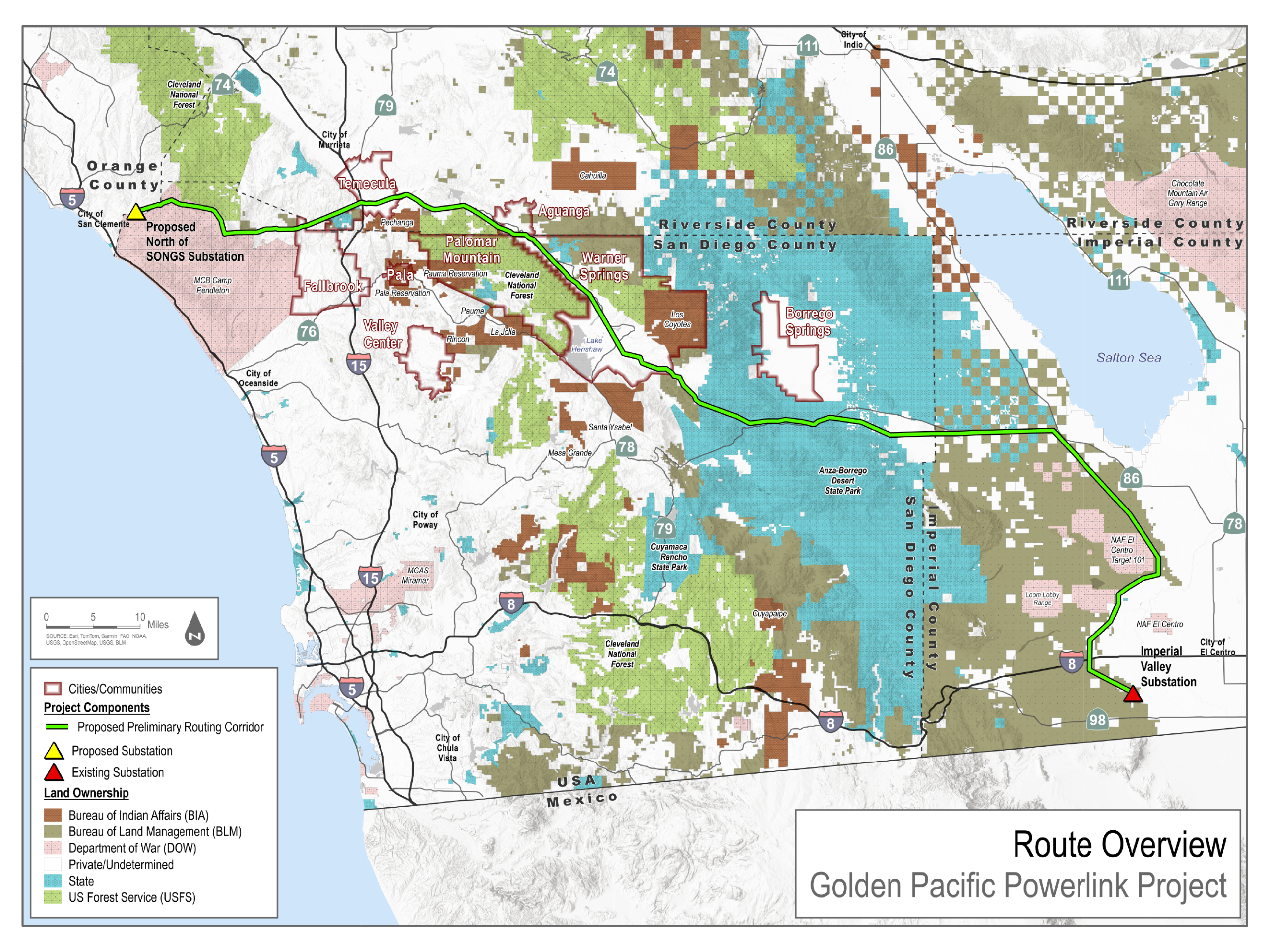
SDG&E calls its route preliminary. It has published maps but no written description, engineered alignment or tower sites.
On SDG&E's own route map, the proposed corridor runs north from the Imperial Valley Substation to 78, crosses Anza-Borrego Desert State Park along that corridor, passes Lake Henshaw, then follows 79 northwest through Warner Springs and Aguanga to Temecula, and runs west to a substation SDG&E proposes north of San Onofre, near San Clemente.
Sources: SDG&E; Anza-Borrego Foundation
Pala, Pauma Valley, Rincon and the north edge of Valley Center are on the South Mountain Alternative, not the proposed corridor. Descriptions from before August, when SDG&E showed its alternatives, put them on the main route.
Sources: SDG&E; Valley Roadrunner
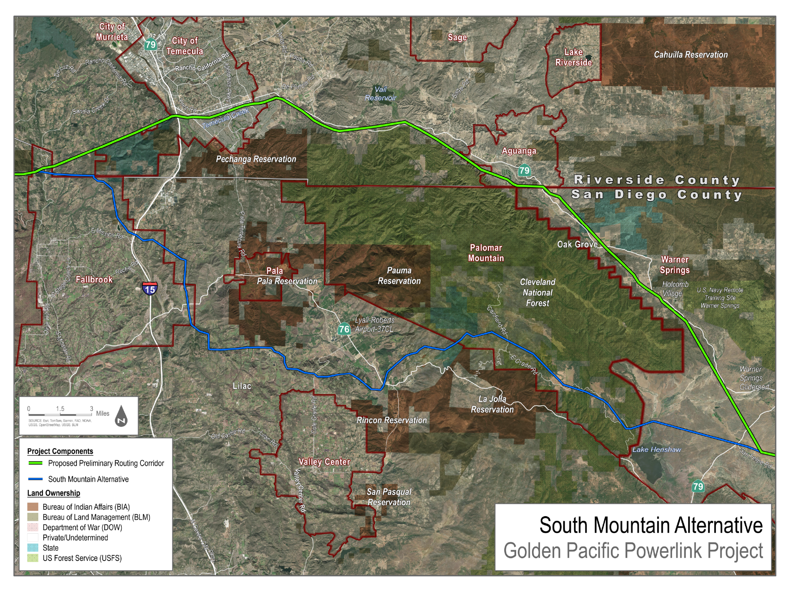
In August SDG&E presented three alternative routes. It has not published their lengths or written descriptions.
- South Mountain
- Montezuma Grade
- Imperial Valley West
Source: SDG&E, via the City of Temecula
Every route puts this line through someone's community. This hub does not argue for moving it onto anyone else.
More maps
- Project vicinity map (preliminary route, no alternatives)
SDG&E
- Alternative route map proposed by SDG&E
City of Temecula
- Golden Pacific Powerlink
SDG&E
Is my property near it?
Put your home on SDG&E's own maps, all seven of them, laid on a map you can zoom. Nothing you type is saved.
Save Pauma Valley also traced the South Mountain Alternative, in English and Spanish: its route map.
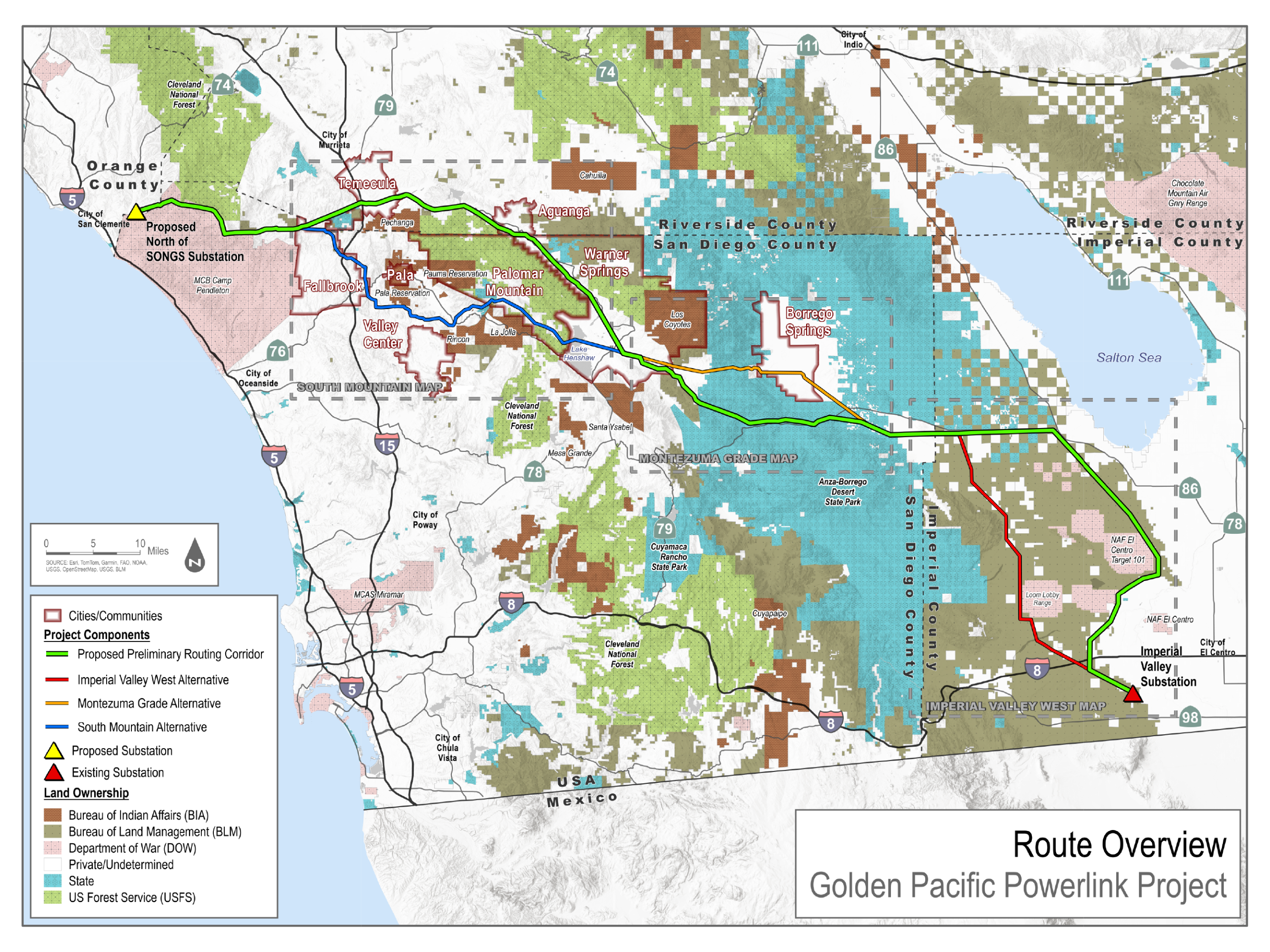
SDG&E's own map. Green is its proposed preliminary corridor; red, orange and blue are the three alternatives. SDG&E's project site offers its maps as images, without map data, so the hub shows its drawing rather than redrawing the line. Tap the map for the full-size file.
Source: SDG&E
May 18, 2023
CAISO's board approves its 2022-2023 transmission plan, which includes this line as a policy-driven project.
April 29, 2024
After a competitive solicitation that SDG&E also bid in, CAISO selects Horizon West Transmission, a NextEra Energy company, to build it.
August 29, 2025
CAISO approves Horizon West handing the line to SDG&E. Horizon West keeps the new substation at the western end.
September 25, 2025
SDG&E gives the CPUC its 12-month notice that it will apply.
Source: California Public Utilities Commission, via the City of Temecula
April 2026
SDG&E begins public outreach and publishes a preliminary route.
Sources: SDG&E, via the City of Temecula; Anza-Borrego Foundation
August 2026
SDG&E presents three alternative routes, which it calls the options that currently appear feasible.
Sources: SDG&E, via the City of Temecula; SDG&E
October 14, 2026
SDG&E's last in-person open house, in Borrego Springs. Its online survey stays open.
Sources: Connecting with communities; Learn more
By the end of 2026 (expected)
SDG&E files its application with the CPUC, which opens the formal proceeding. SDG&E told KPBS in September it would file by mid-November; the CPUC's page, updated in October, says by the end of 2026. The first deadlines follow, each starting at its own stage.
Sources: KPBS; California Public Utilities Commission; SDG&E
2029 (expected)
SDG&E expects a CPUC decision, with construction starting in the fall.
Source: SDG&E
SDG&E needs a Certificate of Public Convenience and Necessity from the California Public Utilities Commission. Once it applies, the CPUC runs two tracks at once: an environmental review under the California Environmental Quality Act, and a formal proceeding before an administrative law judge. The five commissioners vote at the end.
Sources: Opportunities for Public Participation in Golden Pacific Powerlink Project; Golden Pacific Powerlink project page
SDG&E says the U.S. Bureau of Land Management would run a parallel federal review, because part of the route crosses federal land. We have found no announcement from BLM yet.
Source: SDG&E, via the City of Temecula
The rule that shapes the fight
Under rules adopted in 2025, when the state grid operator (CAISO) has found a line is needed, the CPUC presumes the need and defers to that finding. The presumption can be rebutted, but it means the case will turn mostly on where and how the line is built: the route, fire risk, and the environmental impacts.
Source: California Public Utilities Commission, via the City of Temecula
In June 2026 the City of Temecula put these questions to CPUC staff, who answered in writing. The questions are shortened here; the answers are theirs, word for word.
- Has SDG&E met with the CPUC before filing, as the rules require?
“On September 25, 2025, SDG&E provided the CPUC a 12-month notice of its intent to file an application. An initial pre-filing meeting between the CPUC and SDG&E occurred on October 13, 2025. Since that time, the CPUC has been engaged in pre-filing consultation with SDG&E, consistent with the requirements of GO 131-E. A CPCN application is currently anticipated to be filed in the fourth quarter of 2026.”
CPUC staff, answering the City of Temecula, June 17, 2026
- Can the route still change before SDG&E files?
“The CPCN Applicant may identify alternate routes, however since the CPCN has not yet been filed with the CPUC we can’t say if this will be a part of the Application. The City may communicate directly with SDG&E regarding any route alternatives.”
CPUC staff, answering the City of Temecula, June 16, 2026
- Will SDG&E's application include alternative routes?
“A CPCN application for a major transmission project typically includes the applicant's proposed route; route options considered; supporting environmental and engineering analyses. CPUC won’t know until the Application is filed.”
CPUC staff, answering the City of Temecula, June 16, 2026
- Can the CPUC change the route SDG&E proposes?
“During environmental review, CPUC staff and environmental consultants can evaluate whether route modifications, alternative routes, or design changes could reduce impacts.”
CPUC staff, answering the City of Temecula, June 16, 2026
- When can a city, or anyone else, weigh in?
“I suggest the City communicate with SDG&E before the CPUC filing. Once the Application is filed the City can participate in the proceeding by becoming a party or filing public comments.”
CPUC staff, answering the City of Temecula, June 16, 2026
- Which agency leads the environmental review?
“For transmission projects requiring a CPCN, the CPUC often serves as the CEQA lead agency. The NEPA lead agency, if any, would depend on the federal approvals required for the project.”
CPUC staff, answering the City of Temecula, June 16, 2026
- Who prepares the environmental studies, the CPUC or SDG&E?
“GO 131-E now allows applicants to submit applicant-prepared administrative draft CEQA documents to accelerate review. GO 131-E was adopted specifically to move environmental review earlier and shorten permitting timelines. The review schedule for any particular project depends on the contents of the application and the scope of environmental review required.”
CPUC staff, answering the City of Temecula, June 16, 2026
- Why did the project pass from Horizon West to SDG&E?
“The CPUC's role generally begins when an entity seeks permitting authority through a CPCN. California ISO (CAISO), not CPUC, would be the appropriate entity to explain the competitive solicitation process, project sponsorship, ownership transfers, and any reassignment decisions.”
CPUC staff, answering the City of Temecula, June 16, 2026
- Does FERC have a say?
“The CPCN and CEQA approvals for siting the project remain primarily under CPUC jurisdiction. The Federal Energy Regulatory Commission regulates interstate transmission rates, transmission planning policies, and aspects of grid reliability.”
CPUC staff, answering the City of Temecula, June 16, 2026
Source: California Public Utilities Commission, via the City of Temecula
CAISO, the state grid operator, decided the line is needed. Here is its case in its own words, what it compared, and what the record says about options that would put a line through no new community.
CAISO's case
CAISO approved the line in May 2023, in its 2022-2023 Transmission Plan, as one of 21 policy-driven projects that it says “are needed to meet the renewable generation requirements established in the CPUC-developed renewable generation portfolios.” Its studies name an “East of Miguel” constraint: without new transmission, none of the planned generation behind it is deliverable, in zones it lists as Arizona, Baja, Imperial and Riverside East.
Sources: 2022-2023 Transmission Plan, board-approved; 2022-2023 Transmission Plan, Appendix F (policy-driven assessment)
What CAISO compared
Every alternative CAISO compared includes new lines. In its words: “All of the alternatives include new transmission lines and all of these transmission lines are considered to be very challenging in terms of obtaining a CPCN. HVDC Alternatives B1, B2 and B3 would allow undergrounding some of the overhead transmission lines and address visual environmental impacts but would have a significantly higher cost.” For the East of Miguel constraint, its study rates moving the portfolio's planned battery storage “Not adequate.” SDG&E says every mile of its line would be overhead.
Sources: California Independent System Operator; San Diego Union-Tribune
Options that build no new corridor
Reconductoring and grid-enhancing technologies
California's SB 1006 (2024) finds that “Reconductoring existing transmission lines with advanced conductors in existing rights-of-way can be accomplished at a fraction of the cost of building new transmission lines and are therefore often quite cost effective.” It requires each transmission utility to study which of its lines can be reconductored. It also says “This section does not affect any project previously approved by the Independent System Operator,” and CAISO approved this line in 2023.
Sources: California Legislature; California Independent System Operator
Local generation and storage
For the Sunrise Powerlink in 2008, the CPUC's environmental review ranked three alternatives, two of them local generation, ahead of the route the Commission approved: “The Final EIR/EIS ranks three alternatives as environmentally superior to the Final Environmentally Superior Southern Route – the All-Source Generation Alternative, the In-Area Renewable Alternative, and the LEAPS Transmission-Only Alternative.” The Commission found all three “infeasible for, among other things, meeting California’s broader policy goals.”
Existing corridors
The City of Temecula asked SDG&E which opportunities “to parallel or re-conductor existing routes and infrastructure were considered before proposing a new 500-kV corridor.” SDG&E's September 16 reply says “CAISO evaluated alternatives to a new 500 kV transmission line, including alternatives involving existing transmission infrastructure and associated cost estimates, before determining that a new transmission line was the most effective long-term solution.”
Sources: City of Temecula; SDG&E
The hub argues for no route over another. Once SDG&E files, environmental scoping is where anyone can name the alternatives the report must study.
In its own words. We quote the proponent fairly because our credibility depends on being the most accurate source about this project, including SDG&E's side of it.
On why the line is needed
“California's transmission planning process has determined that additional transmission capacity is needed to keep the electric system reliable and resilient.”
Source: SDG&E
On who decided the line should be built
“reflecting a broader system need rather than a concept advanced by the utility”
Source: SDG&E, via the City of Temecula
On who the power is for
“not for any individual customer or industry”
Source: SDG&E
On wildfire
“The Golden Pacific Powerlink will benefit from this expertise, including SDG&E's award-winning wildfire safety program.”
Source: SDG&E
2007: three fires from SDG&E lines
Cal Fire and CPUC staff found that SDG&E facilities ignited the Witch, Guejito and Rice fires. The Witch Fire started on a 69 kV line between the Santa Ysabel and Creelman substations, which the CPUC classes as transmission. Guejito and Rice started on 12 kV distribution lines. The CPUC refused to let SDG&E charge customers $379 million of the costs.
The damage
The Witch and Guejito fires burned together across about 198,000 acres, destroyed an estimated 1,141 homes and killed two people, according to SDG&E's own summary of Cal Fire's findings.
The hazard map
On CAL FIRE's 2024 State Responsibility Area map, Warner Springs, Santa Ysabel and Aguanga all fall in the Very High Fire Hazard Severity Zone, the highest class. We checked each location against the map data.
Source: CAL FIRE
“we find that all routes that would traverse Anza-Borrego are unacceptable”
In 2008 the CPUC approved SDG&E's Sunrise Powerlink, also a 500 kV line, but not through the park. Its environmental review found that SDG&E's proposed project, which crossed the park, had 52 significant, unmitigable environmental impacts. The Commission approved a southern route instead.
Every route SDG&E has shown crosses Warner Springs, the largest hotspot of genetic divergence in a 2008 study of southern California wildlife.
“This hotspot is the largest within our divergence multi-species genetic landscape, and sits at the crossroads between several mountain ranges and the desert.”
The Vista Irrigation District says SDG&E's preliminary preferred and alternative routes “all cross District owned land at Warner Springs,” with towers just under 200 feet high on an easement 200 to 250 feet wide.
Source: Vista Irrigation District
What the study found, what building the line involves, and what to ask forWildlife groups, agencies and researchers to contactWhat is established and what is not. We do not overstate this, and we ask the groups not to either.
SDG&E's magnetic field estimates
| Distance from the line | Magnetic field |
|---|---|
| Centerline | 86.7 mG |
| 100 ft | 12.6 mG |
| 200 ft | 3.2 mG |
| 300 ft | 1.4 mG |
Source: SDG&E
The World Health Organization's cancer agency classes power-frequency magnetic fields as "possibly carcinogenic to humans" (Group 2B), based on a link with childhood leukemia at long-term exposures above about 3 to 4 mG. WHO also says that evidence is not strong enough to be considered causal.
Source: World Health Organization